Saturday, October 23, 2010

A bike ride through pine flatwoods and cypress wetlands

On my last trip to Florida I did a blog post on the Everglades. This time I thought I would share the haunting and beautiful landscapes of the pine flatwoods and cypress wetlands of Pasco County from one of my late afternoon bike rides. I have had to resort to my "point-and-shoot" camera as I am not sufficiently coordinated to ride with the larger digital camera and multiple lenses. Never-the-less, I hope you will enjoy these.


At the end of September, the wetlands were at their highest water level. Near the end of October, however, they are beginning to dry out.

Pasco County is less developed than the counties to the south. I do pass some interesting houses on my rides but would not feel comfortable taking photos. Pasco is a bit like Fairbanks in that you don't want to exhibit too much interest or curiosity outside of more densly populated areas as you may end up getting shot (just kidding, sort of).


There are over 1,000 Florida wetland plants. I have the book, Florida Wetland Plants: An Identification Manual (Tobe, et. al.), but in flipping through it a few times I couldn't find a picture that resembled this plant. It is quite common in Cypress Creek and very colorful, though.


The cypress have all lost their leaves (that look like needles), and the swamps are looking austere -- as they do all winter.


An example of the invasive vines that are choking out indigenous vegetation throughout Florida.


After half an hour's ride from my house I come to the Cypress Creek Water Management area. It has over 15 miles of paved roads and unpaved trails. The road is only open to official water management motor vehicles. Bicycles, horses, runners, and hikers have open access through a narrow path alongside the gate. It is full of wildlife and beautiful examples of Central Florida habitats.


Lots of saw palmetto


There are seven species of true pine trees in Florida, and many of them are found here in the Cypress Creek area.


This young deer and I surprised each other. I actually saw several deer on this ride but this is the only one I managed to catch on camera. Not a great photo, but you get the idea.


A typical late afternoon landscape.


Among the thousand species of wetland plants are MANY grasses. These turn this lovely pink/lavender at this time of year.


Flowering saw palmetto.


Whereas in Alaska you are likely to see Moose and Dog Team Crossing signs, in Cypress Creek you have to watch out for gopher tortoises.


Another pristine landscape.


Classic pine flatwoods vegetation.


A great blue heron at the side of a pond.


Golden rod at dusk.


The full moon last night on arrival back at the house at about 7:15 pm.

Although I am looking forward to getting back to Fairbanks and the beginning of winter, I must admit to being a little sad to give up these spiritually renewing bike rides (and of course, seeing my sister and Florida friends).

Sunday, September 12, 2010

Update to last post

It has been pointed out that since my new cabin looks so much more, shall we say, substantial that some of you may be wondering if it is actually "dry". The answer is yes.


This is the exit on the Steese Highway from Fox spring where I still haul my water. It is my impression that this fall has been more striking and colorful than last year.


The Spring in Fall


The Outhouse

Saturday, September 11, 2010

End of summer, end of fall, end of everything...

at least until the first snowfall. Summer and Fall seem to come to an end simultaneously in Fairbanks. Next weekend will be the last farmers' market, Friday will be the last day the Pita Place is open, and Hot Licks Homemade Ice cream on College will close shortly thereafter. Today is beautiful -- 60 F, bright sun, and full fall colors. Everyone and their dogs are outside.


A rosy dawn ...


Willow Run on a gray day after the rain.


My old cabin


... and my new one.


The cabin is twice as large and much brighter. You can see the sun rise from the window facing east in the loft and see it set from the window facing west. The small window above the bed should provide an excellent view of the northern lights in winter. This is a vast improvement over having to walk out to the road at 2:00 am to see them.


Somewhat higher above the ground it has two balconies. This one is facing south.


The chickadees frequent the bird feeders -- but so do the squirrels. I think I have already gone through about 20 pounds of black oil sunflower seeds in a month.


The last flowers of the season from in front of the public library.


They are a feast for the eyes (to coin a phrase).


The height of fall colors on Ballaine Road at the bottom of Goldstream Valley.


Close-ups from a walk in the woods ...


It is difficult to get a really good photo of moss (not that this is, I just liked it).


On this walk I didn't see another soul -- and I'm glad there are no bears around here.


Ballaine Lake.


The Pita Place

--included especially for Ann. They have the best falafels ever. I had my last one of the season today.


Creamer's Field

There are still Canadian Geese around but all of the sandhill cranes have gone.


The Tanana Valley Farmers' Market


Knit hats are reminders that winter is not far away.


Local honey.


Wonderful 'Alaskan Grown' veggies.


Remind you of anyone?


The road ends at the cabin.


The decoration above the window is a partial caribou antler I bought at the fair this summer. Rosemary's comment was "Whatever you paid for that, it was too much".


The prayer flags have also moved.

'Tashi deleg' to all and I hope to see many of you in Florida very soon.

Tuesday, July 6, 2010

Dalton Highway to Deadhorse/Prudhoe Bay


The Dalton Hwy or "Haul Road" carries you as far north as you can go by road -- period. It has been featured on Ice Road Truckers during winter when it is covered with snow and ice. The summer finds it a mix of some fairly decent pavement, but most of it is rough sections of rock, mud and gravel. Driving is further complicated by ongoing road work during the summer season. My overall impression of the road is when it is good it is very very good, but when it is bad it is horrid. I have Ann to thank for discouraging me from driving too far up on my own.

It is 500 miles from Fairbanks to Prudhoe Bay which lies 300 miles above the arctic circle on the shore of the arctic ocean. You cross the mighty Yukon River, pass through the stunning Brooks Range, and continue on across the vast north slope on arctic tundra (adjectives fail here). Always in close proximity to the Trans-Alaska Pipeline, one is ever mindful of the strange interface between technology and wilderness. Surprisingly (although I am sure many would violently disagree) I found a certain beauty in this silver ribbon snaking along the road through some of the most pristine country known to man. I know, I know, get to the photos ...


The Arctic Caribou Inn is the high end of accommodation in Deadhorse -- described in the Lonely Planet Guide on Alaska as a "dystopia". No one actually lives in Deadhorse permanently. Laborers work two weeks on, 7 days a week, alternating with two weeks off. It is difficult to convey the ambience.


This sign was taped on the back door entrance near my room. I must admit to a certain uneasiness when I went out at 4:00 am the next morning to "look around"


This is the back door entrance to the corridor on which my room was located. The hotel is quite pricey but given the remoteness of the location and the extreme climatic conditions, you come to think of it as a bargain -- at least it has hot showers. I will mention, however, that the only news station available on cable TV here is FOX.


There is currently a lot of roadwork being carried out on the Dalton. By chance, I was lucky to have chosen the 4th of July weekend to go up as most of the workers were off and there were no major delays.


Every summer there are extensive fires along the road. This hillside is covered with fireweed -- the first plant to return after a fire. Although the photo came out somewhat pale, the entire landscape is a vibrant fuchsia.


At Mile 56 on the Dalton, a 2290ft. wooden bridge spans the Yukon River. Here you see the barge docked alongside the bridge. The barge delivers supplies to villages along the river.


This is Yukon Camp, one of the few places you can sleep and/or eat on the road. The young man smiling in the foreground was our amazing driver -- and a safer driver I have never ridden with. There were only two of us in the van on the way up. My fellow passenger was a researcher from California heading up to spend 2 weeks at the University of Alaska, Fairbanks, research station at Toolik Lake.


A moose the likes of which are not commonly observed on Willow Run.


The pipeline snakes though the wilderness alongside the road. In the few places where it doesn't threaten the permafrost it is buried underground.


The road passes through Atigun Canyon and follows the Atigun River on its way to Atigun Pass in the Brooks Range. Here you see the pipeline parallel to the road looking down into the canyon.


The views on the road through Atigun pass defy description. I have selected just a sampling of photos from this area of the trip.


Here, again, you can see the pink tapestry of fireweed on the slope.


The mountains of the Brooks Range were partially covered in low cloud -- enhancing their mystical appearance.


The Franklin Bluffs

These bluffs, pingos, ice wedges, and other features found on the arctic tundra are described in great technical detail in a series of Guidebooks produced by the International Conference on Permafrost. http://www.geobotany.uaf.edu/nicop/docs/gb009.PDF is a link to one produced in 2009. The photos in the book are so similar to many of mine it is almost scary. On this section of road we saw a herd of 8 musk oxen, tundra swans, orange-footed geese, more caribou, and a guy with a donkey (?). I wish the photo of the musk oxen would have come out better but even with a telephoto they were pretty far away.


The road heading across the north slope toward Deadhorse


Wildlife seems to have reached some kind of accommodation with the industrial activity in Deadhorse. Here you see caribou relaxed in close proximity to aluminum clad warehouses.


These vehicles, called rollagons, are used on the tundra to avoid damaging the surface. The following link provides information on how they work: http://www.thefreelibrary.com/Gentle+yellow+giants:+prowl+the+Arctic:+CATCOs:+truly+a+cat+for+all...-a0122407776


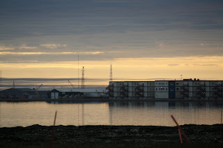
Deadhorse is centered around Lake Colleen. I found it not without a kind of austere appeal -- even if it is a dystopia. The building across the lake is one of the newer "units".


More wildlife in Prudhoe Bay. This is the closest I have ever been to caribou


... up close and personal.


Apparently these sand dunes on the edge of the ocean become dens for grizzlies during the winter


The Beaufort Sea, at last ...


One guy went swimming. I didn't...

It may seem strange, but I would be happy to repeat this trip with our driver, tomorrow. As luck would have it, I ran into someone I know from Fairbanks in Coldfoot Camp who got the name of a trucker who would be willing to take me up to Deadhorse in winter. I can't wait...